| ||||||
|
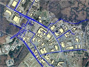
Professional Land Survey ServicesSynthegis®, Inc. is a leading provider of Geographic Information Systems (GIS) and Mapping and Professional Land Survey services. Experienced in assisting commercial and government clients with comprehensive services, Synthegis® offers smart, efficient solutions that make sense in a complex world. Synthegis®' team has performed GIS and survey projects throughout the Washington DC metro area, ranging from geo-database design and mapping, spatial and non-spatial database integration and other services that complement our new service offering of land survey services. The land survey sector has taken notice of new technologies such as ESRI's ArcGIS Survey Analyst. Synthegis®' team of surveyors and GIS professionals are a natural complement to projects requiring expertise in both arenas. Our licensed land surveyors bring a combined 68 years experience in the surveying industry. Their past performance and subject expertise has spanned across bridge construction and rehab, sub-divisions, and surveying for road construction. In addition, our team has relationships with other survey professionals to complete projects on time and under budget, no matter the resource requirements. Synthegis®' support of land survey requirements encompasses the following: Surveying Services
Synthegis®' trained, experienced and highly-skilled field technicians recognize the importance of quality, cost efficiency and timeliness. Field technicians are involved in planning, reviewing project specifications and creating accurate, detailed field maps. Our qualified technicians stay current with today's industry standards and technologies and are asked to meet rigorous demands, adapting to a variety of conditions and persevering to get the job done. Synthegis® understands the complexities and liabilities involved with survey work. We want to assure our clients that our team – with its combined 68 years of experience – brings top notch knowledge and experience to every project, ensuring that our clients can have full confidence in our abilities to perform the work as required. |