 | ||||||
| News | Events | Management Team | Corporate Profile | Careers |
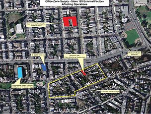 |
About UsFrustrated by the inability to simultaneously combine and interpret geographic information and business data, we founded Synthegis in 2004 to move GIS beyond mapping into a strategic decision-making tool that exposes geographic relationships to a broad group of managers and executives across a corporation.
Synthegis takes existing information — GIS or spatial data, corporate, customer and competitor-specific data — and channels it through proprietary predictive models and geostatistical analysis.
The result is an advanced data integration portal that lets corporations graphically overlay and interpret the spatial component of their combined business (nonspatial) and location data based on company-defined geographic parameters.
|